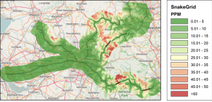
Case study: Trans Pennine System
The Northern Hub is a rail project across Northern England that aims to increase train services and reduce journey times between the major cities and towns by electrifying lines and removing a major rail bottleneck in Manchester.
In 2011 Network Rail commissioned a series of SnakeGrids as part of this project, commencing with the TPEN11 grid from Liverpool in the west, via Manchester, onto separate branches to Leeds and Bradford in the east. All of these different sections were brought onto one continuous coordinate grid, with a maximum scale factor distortion of 10.1 ppm on the track.
At the same time, two further grids were merged into this at Manchester. MOLEUX11 runs from Manchester via Ordsall Lane to Euxton Junction, and has a scale factor distortion of less than 5 ppm along the route. MOLDOR11 runs from Manchester via Ordsall Lane and the Hope Valley to Dore Junction, with a maximum scale factor distortion of 10.4 ppm.
The result is an interlocking series of coordinate grids – covering a huge area, and yet having barely more scale distortion than a local site grid.
At the points where the grids join, the coordinates agree exactly at a specified point. Away from this point the agreement is typically within 1 – 2 mm up to two kilometres away. In fact, this grid is also designed to share common coordinates with the older WCG05 grid at the point where it intersects.
